
By the afternoon of Friday 22nd June, the tops above the Upper Calder Valley couldn’t absorb any more rain from the relentless downpour that had been falling all day. Roads to the valley turned into torrents, as water gushed out of field gateways and off the moors. According to Steve Sweeney, Calderdale Councillor for Todmorden Ward, this runoff caused the Burnley Road flooding in Todmorden.
“We need a different kind of flood alleviation scheme now. This time, the river wasn’t so much the problem,”
explains Councillor Sweeney, who is Calderdale Council’s member of the Yorkshire Regional Flood and Coastal Committee (YRFCC).
“The floodgates in Todmorden were opened in good time, by request of the emergency services. The Environment Agency’s flood defences on the river effectively stopped the river from flooding in Todmorden – even though, further down stream in Hebden Bridge and Mytholmroyd, the River Calder did burst its banks.”
The 9th July floods in Hebden Bridge were also caused by torrential run off from the hillsides above the valley – not by the rivers flooding.
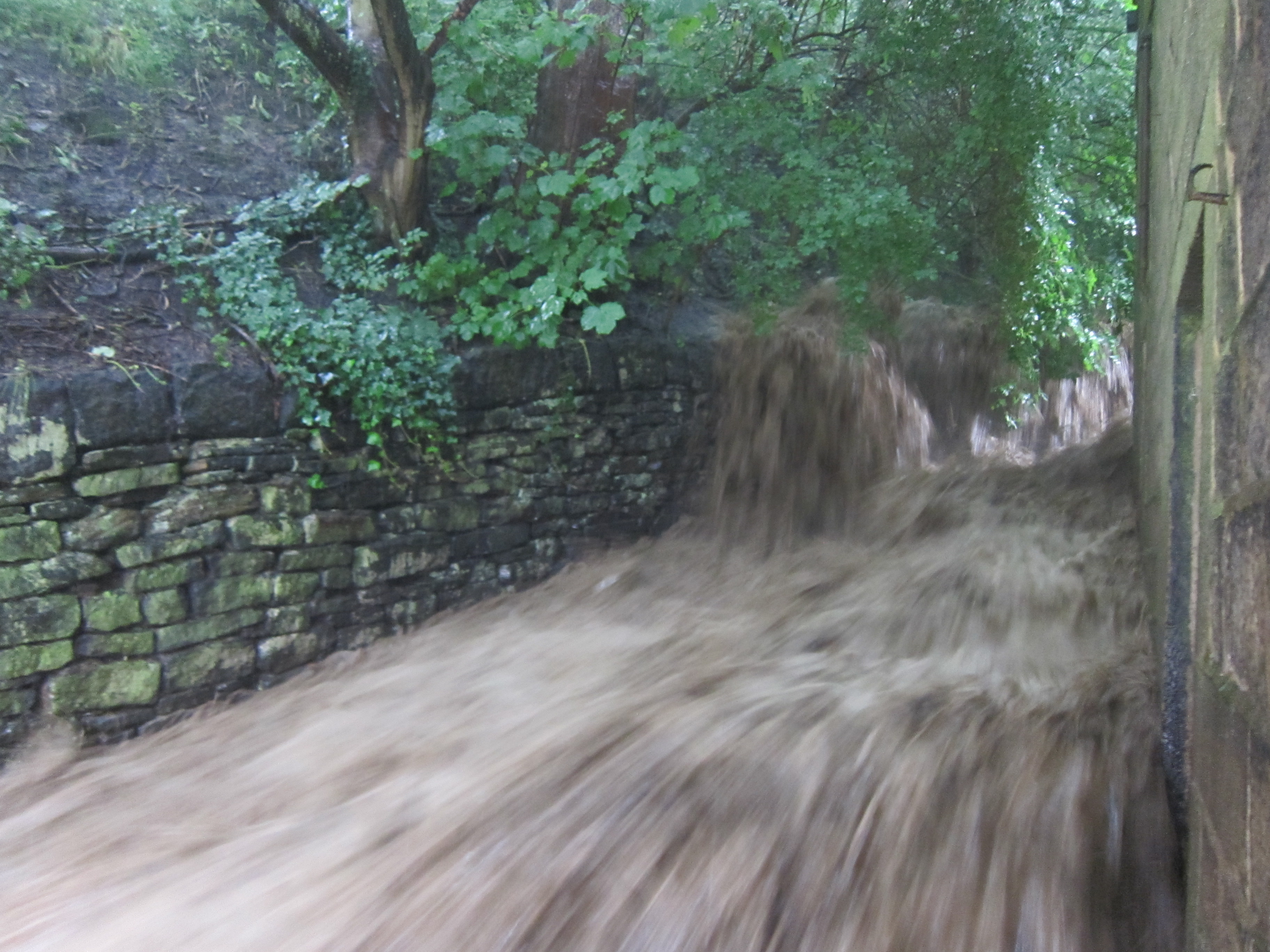
MVI_0007 – this video by Geoff Tansey, of the driveway turned into a torrent – opens in another window. Usually, a little stream flows underground here, but the culvert couldn’t take the volume of water. Councillor Sweeney is clear that,
“The Council needs to look at giving Upper Calder Valley drains and culverts more frequent checks.”
But even if the culvert had been perfectly clear, it almost certainly couldn’t have taken that volume of water.
Restoring degraded tops and hillsides will slow run off
So what can be done to help the tops and the hillside soils to hold more water and slow run off into the valley? Following the 2000 floods, Treesponsibility’s Dongria Kondh in Hebden Bridge was inspired to start work on a watershed management project, which came to be called SOURCE.
“Treesponsibility was initially a way of talking to people about climate,”
Dongria says.
“It started as an attempt to get into tree planting to offset carbon emissions, at the same time as reducing them. The 2000 flood was like a slap in the face. Immediately afterwards, we starting planting big sites and thinking strategically about trees and flooding.”
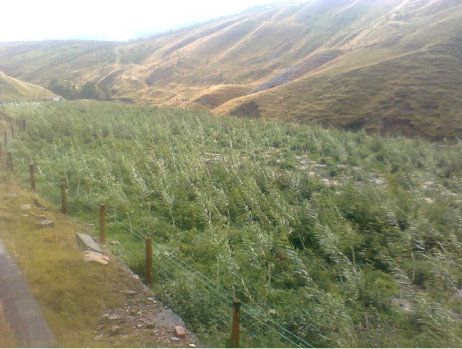
Tree planting helps reduce and repair soil erosion, and since 2000, about half of Treesponsibility’s planting has been in the badly-degraded watershed area which is the source of three rivers: the Irwell, and the Yorkshire and Lancashire Calder Rivers. The erosion in this area meant that the soil was incapable of holding rainwater, which just washed away more and more soil into the rivers.
The SOURCE project is a trailblazer for accessing Environment Agency Funds for “integrated catchment management”, including tree planting. (“Integrated catchment management” means managing river basins or watersheds by taking account of how water quality and quantity is affected by:
- land use management
- the actions of various different people and organisations, who need to communicate and work together to be effective
- the fact that actions at one place in the catchment will have an impact on other parts of the area)
After securing funding, since autumn 2011 SOURCE has radically upped the scale of its watershed management. In the watershed area, SOURCE now makes a generous offer of erosion control at no cost to large landowners, farmers and commoners. It also provides free fencing to keep livestock off the land while the trees are growing and the land’s recovering.
Its main site for tree planting in autumn 2012 is 19 hectares. Pending finalisation of arrangements, the SOURCE project hopes to plant 22 thousand trees there between autumn 2012 and spring 2013.
“We’re constantly looking for more land,”
says Dongria.
“We hope more landowners and commoners alike will take us up on our free watershed management offer.”
So how effectively can watershed management reduce soil erosion and runoff into the valley? Dongria points out that,
“ Given the outlook on climate, the total failure of the 20 year process since the Rio Earth Summit in 1992, people are going to get flooded. So we have to take responsibility. We have to do watershed management – we can’t prevent flooding, but we can make the difference between disaster and recoverable flooding.”
A double positive – low carbon biofuels and water table management
A recent study has shown that it makes carbon sense to grow biofuel crops on “relatively wet but highly degraded land”. This is because biofuel crops that are grown on degraded land will absorb more carbon dioxide from the atmosphere than the poor quality, sparse vegetation that would otherwise grow on degraded land. (Whereas growing biofuel crops on land which already carries other crops won’t increase the amount of carbon dioxide absorbed from the atmosphere.)
Growing biofuel crops like willow, that are very thirsty and lower the water table, also makes it possible for the land to hold more water when it rains, and so reduces run off and erosion.
Conserving peat bogs
Moors for the Future is also working to restore damaged and degraded moorland above the Calder Valley.
At Turley Holes, near Hebden Bridge and Mytholmroyd, Moors for the Future is carrying out conservation work on the blanket bog, which is a Site of Special Scientific Interest.
It has fenced the worst areas of bare peat to stop grazing, and adding heather brash (heather that’s been cut and harvested from the moors in winter, and is then spread over the most damaged areas of peat), lime, fertilizer and nurse crop grass seed.
Future conservation work will include gully blocking to increase the water levels, blocking peat pans with heather bales to slow the water flow and help to revegetate the bare peat, and spreading more heather brash.
Walshaw Moor
Earlier this year, Natural England made a controversial decision to drop its legal action against the land owner of Walshaw Moor for burning peat bog – a practice carried out in order to make the moorland more suitable for grouse. It also dropped its public inquiry that aimed to ban peat bog burning.
Soft flood defences on farmland
In Belford, Northumberland, the Environment Agency and Northumberland University have worked with local farmers to protect the town from flooding, by building ‘soft’ flood defences. These use the contours of the farmland to make temporary ponds to store water and stop it running off the land into the town.
They’ve built storage ponds, wetlands, beaver dams and willow features along the riverbank. These trap sediment, improve water quality, create new ecological zones and slow the flow of water.
I have read the above article and endorse everything that has been said, I think that all the different flood prevention schemes in Yorkshire should come together. ‘Yorkshire Slo9w Water ‘ that would be the main aim, I live in York so I have seen the devastating effect of ‘ Fast Water .